|
 Thursday, July 1, 2010 Thursday, July 1, 2010
Valdez wasn’t a port we had planned to visit, but we decided to see if we could find someone to repair the steering on the dinghy. Along the way, we had an athletic school of Dall porpoise riding with us, swimming sideways and upside down in our bow wake. Surprisingly, for a town that largely is centered around fishing and its harbor, we struck out on finding anyone in Valdez who could fix the steering … or even a place where we could buy parts. What we DID find, however, were two delightful purse seiners -- the Angjenl from Peterburg, and the Raven from Seward – that we tied off of for two days because the harbor was filled beyond capacity with fishing boats waiting for an opener. 
(Note in the picture to the right, a seiner is a fishing boat that can be configured to catch salmon, halibut, crabs, etc. For salmon they use a seine … a long net lined with floats on one side which is released behind the boat and dragged with a skiff into a large circle, where they then pull in the bottom of the net like the drawstring of a purse, before reeling it up and into the back of the boat … fish caught in the net drop into the hold of the boat.) 
As we pulled in to tie off the Angjenl, its skipper, Ryan, was quick to offer us some fresh salmon if we were willing to give him a tour of our boat. Deal!!! (I figured this may be my surest way of securing some fresh salmon since we haven’t had much luck trying to catch any ourselves).
Cory, the skipper of the Raven was equally amiable, and even spent an afternoon helping Roland tear apart the steering on the dinghy and suggested the names of some folks in Seward who we could contact for parts since Valdez was a bust. Thursday evening we invited the crews of both boats over for a dinner of Cincinnati Chili … eight hungry guys!!! I doubled the recipe and made enough for 16 and still barely had enough. 
It was pretty entertaining getting to know both crews and listening to their stories, especially the two younger members on Angjenl, Dan and Evan, who gave me a tour of their boat. I walked away with a new appreciation for the creature comforts of Engelenbak. 
When I commented that single girls in the “lower 48” would appreciate all the young single men there seems to be in these Alaskan fishing communities … they were quick to explain to me the chances a girl had finding a guy in Alaska … “The odds are good … but the goods are odd.” Very cute (both the guys and their joke)! 
Over the course of the evening, Sam, an expert fisherman and Ryan’s first mate on Angjenl, generously shared some fishing tips with me. His father owns a tackle shop in Petersburg, so not only did he show me a special way to hook a herring on a lure so it spins through the water when you’re trolling, but he also gave me custom made “sliders” and shiners. His other secret piece of advice … soak your bait in WD40 … the smell attracts both salmon and crabs. Who knew! The straightforward warmth and generosity of both crews was certainly the highlight of our time in Valdez.
Wednesday, June 30Good Friday historically has not been good to Alaska. On Good Friday in 1964, Alaska experienced the largest earthquake in North American history, lasting 5 minutes and registering a record 9.2 on the Richter scale. The epicenter was in Prince William Sound. As the ocean floor shifted, causing tsunami waves as high as 70 feet that reached as far as Hawaii and Japan, it not only severely damaged or destroyed villages and communities around the Sound, it also forever changed the depths in the Sound, rendering most navigational charts obsolete and permanently uplifting some areas as much as 6 to 30 feet. We were quick to take note that many of our charts for the Sound include warnings that some areas haven’t been recharted since the earthquake in 1964, and therefore may not be accurate. Not comforting when you’re in a vessel with a 7-foot draft.  On March 24, 1989 … another Good Friday exactly 25 years later … the Exxon Valdez struck Bligh Reef in Prince William Sound. Most people remember seeing news images of this environmental disaster, which up until the BP rig explosion in April, was the largest oil spill in U.S. waters in history, releasing 11 million gallons of crude into the Sound. By comparison, the Valdez spill is less than the amount of oil released into the Gulf of Mexico the first two weeks following the Deepwater Horizon explosion … and here’s the real kicker … 20 years later some areas of Prince William Sound are still saturated with toxic oil … and several species, like the herring population, have never recovered.  So it was with great trepidation … which quickly turned to indignation … that on Wednesday as we made our way to the port of Valdez, we sailed past Bligh Reef. Take note in the adjacent photos … Bligh Reef is not only well marked with a lit beacon … it’s 2 MILES LONG and clearly visible if you are navigating properly with charts! You’d have to be blind, asleep … or I guess very drunk … to not see Bligh Reef on a chart. It’s an example of human error at its worst … at a huge cost to both the wildlife and humans who made a living in those waters … and a mere $900 million civil settlement paid out by Exxon over 10 years. Today, 20 years after the spill and major restoration efforts, they estimate it may take decades, and possibly centuries for the oil to disappear entirely. Sadly, one can only imagine the implications for the waters of the Gulf of Mexico and its surrounding ecosystem …
  Tuesday, June 29 Beartrap Bay, 34 miles northwest of Cordova at the end of Port Gravina, is described in one of our cruising guides as the “jewel” of Prince William Sound. But in fact, it is a treasure chest of jewels … a cove encircled in a symphony of waterfalls cascading down every possible crevice like strings of pearls draped loosely over the mountains, magically dropping bead after bead into the water.  It was raining and misty with wisps of low hanging clouds suspended against the summits when we motored into the bay, feeling very much like we were intruders in this private sanctum of wildlife and fauna … escorted in by a couple of sea otters who by appearances were practicing synchronized swimming. Five minutes after dropping anchor a gathering of three eagles appeared on shore, and within 10 minutes there were close to a dozen gathered there … must have been happy hour!  We quickly noticed there was perpetual movement in the water … salmon jumping around us everywhere … sometimes a foot into the air. If only Jim Plona were here to see this! We of course dropped a fishing line, thinking this would be a no brainer ... but the fish were more inclined to play jump rope with the line than take bait. Nothing! Despite the rain, I was determined to at least catch prawn. We had a special recipe from our friend Lincoln that involves mixing prawn pellets with a can of cat food, a can of mackerel, and a certain amount of salmon oil (might as well buy them dinner while we're at it!) … which I stuffed in special bait boxes that attach to the prawn traps. We threw on foul weather gear and headed out looking like real fishermen, in search of 300 feet of water where we dropped the traps … about 4 miles from where Engelenbak was anchored.  The next morning we hooked our electric line hauler onto the dinghy and headed back out to check our traps ... with mixed blessings. The line hauler is a mechanical contraption that tows in the 300-feet of line, and I was thrilled when the traps finally made it to the surface ... our FIRST prawn catch … only 13 but it was a start! And like a savage … I mercilessly ripped the heads off each prawn … saving the tails in the bucket ... and that afternoon we had a delightful prawn appetizer! But there was one complication to our prawn euphoria …we lost the steering on the dinghy and had no choice but to use the oar as a rudder to steer us the 4 miles back to Engelenbak.  Not wanting to spend the rest of our vacation without a dinghy, we pulled anchor the next morning and headed to Valdez in hopes of repairing the steering.
 There wasn't a lot to see crossing the Gulf of Alaska ... just water in all directions. But once we entered Prince William Sound we were surrounded in beauty and wildlife. This slideshow includes our crossing as well as our first port, Cordova, on the east end of the Sound. Also, some amazing photos of our road trip to Child's Glacier and the Million Dollar Bridge. There wasn't a lot to see crossing the Gulf of Alaska ... just water in all directions. But once we entered Prince William Sound we were surrounded in beauty and wildlife. This slideshow includes our crossing as well as our first port, Cordova, on the east end of the Sound. Also, some amazing photos of our road trip to Child's Glacier and the Million Dollar Bridge.
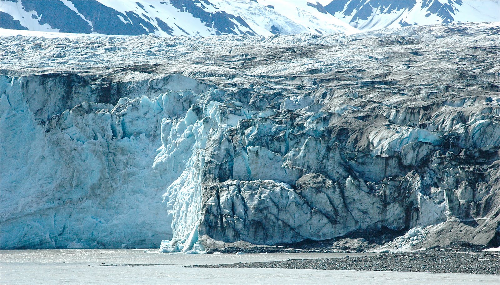
  Saturday, June 26 The Copper River Delta is a 60-mile arc of vast wetlands in the Chugach National Forest, all woven around six glacial river systems with massive runoffs … truly a paradise for those who cherish wildlife and wilderness.  At the advice of many of the locals we met in Cordova, we decided to rent a car and under sunny skies drove to Child’s Glacier, a 48-mile ride from Cordova along the Copper River Highway through the Delta. With binoculars and cameras in hand, we were awestruck by the spectacular pure beauty surrounding us. Twelve miles out of town we traveled past Cordova’s Mudhole Airport (yes, that’s its real name) … and the road turned to gravel from that point on, until you reach the Million Dollar Bridge.   Back in 1910, the Guggenheim brothers and JPMorgan wanted to connect the railway to the Kennecott Mine, a major copper mine that they jointly owned, so they paid … you guessed it … a million dollars to build what since has been known as the Million Dollar Bridge. The bridge collapsed in the Good Friday 1964 Earthquake (more about that later!) and was only rebuilt in 2004 … at a cost of $19 million ... to basically connect to nowhere.  There’s a turnoff just before the bridge that takes you to a viewing platform 400 yards across the river from Child’s Glacier. Child’s is an intensely active glacier with a 300-foot high face that was an awesome sight to both see and hear. Every few minutes you could tell it was in motion when you heard it begin to rumble. And when the rumbling escalated into what sounded like huge thunderclaps, we knew to watch the face for massive pieces of ice calving into the water below.  The park signage particularly warns you to stay on the viewing platform and avoid the shore opposite the glacier, which often has waves over 10-feet high crashing on its banks from tsunamis caused by the calving. Of course Roland ignored that warning, grabbed his tri-pod, and scrambled down to the shore to try for the perfect shot of the calving in action … unfortunately no major calving but the good news is I didn’t lose my captain to a Child’s Glacier tsunami.  Driving back to Cordova that afternoon we stopped along the way to photograph more of the scenery, including a trumpeter swan and a female moose we spotted grazing in the marshlands. What a delightful day trip!
 Wednesday, June 23 Wednesday, June 23Off the beaten path, but considered the fishing capital of Prince William Sound, Cordova took us by surprise. Seven hours after pulling anchor from Montague Island, we arrived in this unique community, the eastern most town in the Sound located on Orca Inlet. The harbor is as picturesque as you’ll find, nestled against a backdrop of mountains veiled in snow and an entrance marked by a convergence of seagulls looking for leftovers from the adjacent fisheries. We were charmed by Cordova before even stepping foot on the docks.  Adding sweetness to our fondness for this dramatic setting, the harbor master informed us our yacht club membership earned us free docking space … which is just one of many reasons we ended up spending four days in Cordova. We immediately were impressed that this was easily the most active, hard-working harbor we’d seen since entering Alaska. The docks were filled with a broad assortment of purse seiners, gill-netters, bow pickers and tenders… all part of a very successful commercial fishing community that never slept. Boats were coming and going at all hours. Walk the docks and you see men at work cleaning their boats, repairing nets or working on engines. In fact, it’s a town where the men out number women at least 20 to 1! A potential gold mine for single girls.  Alaskans have impressed us with their open, honest congeniality … and Cordova was no exception. A plumber we hired to add Freon to our fridge loaned us a book on cruising Prince William Sound and said “just drop it in the mail to me when you’re done cruising here.” We had a good time talking with the crew of the Independence, a larger tender that ferries fish from the fishing boats to the fisheries, who gave us a jar of homemade smoked salmon. They smoke it themselves in birch on their boat and pack it in a “secret recipe” from an Alaskan native mixing brine, olive oil, jalapeños and maple syrup.  Walking through town that day we stumbled upon Copper River Fleece, a very cool outdoor clothing store that was started by a 15-year-old girl in her garage in Cordova in 1995. The garments are all 100% American made with woven trims that feature Tlingit designs created by an Alaskan Native artist. Inspired by both the quality of the apparel and the entrepreneurial spirit of the founder, I bought a matching vest and hat in periwinkle blue.  And to top it all off, we found a fabulous restaurant … the Reluctant Fisherman … overlooking the harbor where our red Engelenbak surely stood out from the crowd. The chef was from Chicago and created an amazing halibut sashimi. Finally, I got my sashimi fix ... Alaskan style.
Sunday…Monday (Summer Solstice) … and finally Tuesday, June 22The Gulf of Alaska covers 592,000 square miles.  Crossing the Gulf, solo in a boat, with a 360-degree view of nothing but water makes your feel really … small. Truth be told … Lovie and I have no fond memories of our first few hours in the Gulf of Alaska. We left Pelican at 10:15 am Sunday morning, and an hour later also left the protection of Lisianski Inlet as we entered the open waters of the Gulf. That’s when all hell broke loose … this 100-ton vessel began to rise and fall in full sweeps, simultaneously rolling back and forth in 6 foot swells. Things started clanging below and anything not secure was soon on the floor or crashing mercifully against the interior walls of cabinets. To the powerful Gulf of Alaska we were nothing more than a small cork in a very, very huge tub of water. Lovie immediately got seasick in the pilothouse and I was feeling a bit green around the gills myself, so we both headed down to the stateroom, the lowest point in the boat, and laid down ... as I began the countdown, contemplating how I was going to survive the 48 hours it was going to take to make the crossing. In the meantime, Roland was up in the pilothouse enjoying every minute of the cruise and taking stunning photos of Mount Fairweather, which we had seen just a few days earlier from its other side … in Glacier Bay. Eventually the seas died down to a steady roll that both Lovie and I learned to tolerate … and even enjoy. By 9:45 am Monday we had travelled 186 nautical miles …. And with all land out of sight, we were surrounded by the solitude of the sea.  That morning I saw my first albatross … sleek 3-foot long birds that glide effortlessly on their 7-foot wingspan over the crest of the open seas with only a rare flutter of their wings. Extraordinary to watch, and I had hours to do so! It’s hard to explain the sensation of being 30 miles offshore alone on a boat. I thought I’d be terrified, but the weather was magnificent with no wind to speak of, and I was amazed to find that my body soon acclimated to the up and down, back and forth rhythm of the sea. Roland and I traded off at the wheel, but he captained the boat for the majority of the crossing. When I took the wheel at 1:00 in the morning on Tuesday, June 22, the day after summer solstice, you could still see light over the horizon.  In fact it was never totally dark that evening, and by 3:30 am, the morning sun began to appear. Remarkable. Around 2 am that evening I sawa blip on the radar about 15 miles out, and soon saw the lights of a huge cruise ship, like a floating city, coming toward us and eventually passing about 3 miles to our port side. We made it to the entrance of Prince William Sound by 5:30 am Tuesday and anchored in Zaikof Bay off Montague Island at 8:20 am … a 46-hour, 364-mile crossing from Pelican to Montague Island … with very little wind or weather, we had made good time! And from the looks of things it was worth the crossing.  The view of Montague was delightful, but after 2-days of seeing nothing but water, just about any landscape would be pleasing to the eyes. Even Lovie was happy to be out on deck in sight of land.
We celebrated our first morning in PWS with Bloody Mary’s and breakfast on the back deck and then, bleary eyed and relaxed, both went to bed for a few hours, woke up and made dinner, and then slept again for 11 hours straight … safe and sound in Prince William Sound! 
|
|
|


 Thursday, July 1, 2010


