 |
| Lots of current |
Its name is a bit of a misnomer. For one, the waterway is anything but straight. But rather a series of zigzagging passageways that twist and wind around granite islands, mixed with hidden rocks, riptides, markers, narrows, and very strong currents. For a captain like Roland who loves a challenge … it’s a beaut.
Secondly, despite the “perils” of navigating these waters, the true source of the name results from an incident dating back to 1799 when a party of Aleut hunters camped on the beaches in this stretch of water, ate some of the mussels, and over 100 died from what is now known as paralytic shellfish poisoning.
The Russians named the waterway Pogibshii, meaning deadly, which has since been translated in English … to Peril Strait. The episode is duly noted with other names along the way, such as Poison Cove, the site where the mussels were collected … and Deadman Reach, where the hunters ate their last meal.
 |
| Note lower right.... 12.1 knots |
As a rule of thumb, you can tell the strength and direction of the current by the tilt of the channel buoys. Normally you try to time your entrance into narrow passageways to coincide with slack tide, either at the top of high tide or bottom of low tide, when there is the least amount of water movement.
 |
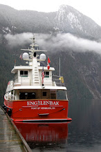
| Sukoi Inlet |
And quite a contrast to the serenity of our anchorage that evening in Sukoi Inlet ...


No comments:
Post a Comment